You’re going on vacation! You’re all packed and ready to go. The family is loaded in the car and your hands are at ten and two. But your GPS won’t load the route. And what’s worse, you threw out your Rand McNally Road Atlas years ago. Now imagine the same scenario for an Amazon driver or emergency response personnel. We take for granted that the map will load, the route will be up-to-date, and the traffic estimate will be accurate. All of these – even the old-school road atlas – are based in Geographic Information Systems (GIS).
1. Understanding GIS More Than Just Mapmaking
When people ask me what I do as a GIS professional, I often reply that I am a mapmaker or cartographer. In reality, however, GIS is much more. It is utilized to fight crime, protect natural resources, prepare for natural disasters, track epidemics, and improve public health. GIS is instrumental in addressing some of our most pressing societal problems.
2. Key Components of GIS
GIS has several key components:
- Data input – gathering spatial data from various sources, including satellite imagery, GPS, ground surveys, and existing maps.
- Data storage – organizing and storing spatial data in a structured way so you can find it easily and analyze it later.
- Data manipulation and analysis – playing with maps, overlaying them, creating buffers, and discovering meaningful information and patterns. This is where the cool stuff happens!
- Data output – presenting your findings in maps, reports, or charts to aid decision-making and communication.
- Mapping and visualization – creating maps or interactive displays that use geographic information to tell a visual story, making it easier for users to understand and interpret complex spatial relationships.

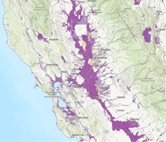
Figure 1: FEMA Flood Hazard Map, Source: ArcGIS Living Atlas
3. Case Study: GIS in Environmental Planning
GIS has an almost infinite number of applications, and environmental planning is no exception. The Council on Environmental Quality (CEQ) and the National Environmental Policy Act (NEPA) require a thorough analysis of the potential significant environmental impacts of any proposed action. GIS is crucial to visualizing the area of potential effect of a proposed action and analyzing the impact that action may have on a variety of resource areas. Beyond simply mapping project boundaries, Scout has used GIS to analyze, among other categories:
- Historic flood zones
- Storm drain networks
- Visual impacts
- Trail locations and distances
- Cultural resources
- Environmental justice communities
4. The Role of GIS in Public Involvement and Communication
Another essential component of the NEPA process is public involvement. Environmental planning documents must be presented in a manner that the public will be able to understand. This is not just a good practice; it is a requirement. Federal regulations dictate that “agencies shall write environmental impact statements in plain language and may use appropriate graphics so that decision makers and the public can readily understand such statements” (40 CFR 1502.8). Maps and figures must be created with the public audience in mind, displaying data in a visually pleasing manner that draws the viewer’s attention to the most important content and makes it easier to understand than paragraphs of text.
5. Ethical Responsibility in GIS Practice
This speaks not only to the importance of keeping maps clear and simple but to the ethical responsibility of the GIS professional. Maps can be employed to manipulate data to support a desired outcome, regardless of what the data objectively indicates. We have seen this played out historically with such nefarious practices as redlining and gerrymandering. The GIS professional must remain unbiased and practice integrity; provide full, clear, and accurate information; and strive to do what is right, not just what is legal. As such, GIS is an essential un-biased component of any environmental planning document.
6. Conclusion: The Broader Impact of GIS
GIS transcends the conventional role of mapmaking, influencing various aspects of daily life and societal challenges. The essential components of GIS form a dynamic system, and its application in environmental planning, guided by regulatory frameworks like NEPA, showcases its pivotal role in visualizing impacts and fostering public understanding. The ethical responsibility of GIS professionals to provide unbiased, clear, and accurate information is underscored, emphasizing the importance of integrity. In essence, GIS not only maps physical landscapes but actively contributes to shaping informed and ethical communities in a meaningful and easily comprehensible . So next time you pull up Google Maps, think about the person behind the screen who helps us all find our way.
My colleagues and I at Scout can be counted on to provide high-quality GIS services to lead the way to your objective! If you have questions or need any support, contact us today at: hello@scoutenv.com.
Stay tuned for more on using GIS in the field to perform accurate site surveys!


