
Apollo 8 launched on December 21, 1968. Three days later, on Christmas Eve, astronauts Frank Borman, Jim Lovell, and Bill Anders became the first humans to witness the Earth rising above the moon’s barren landscape. Small, strikingly beautiful, and floating in the vast darkness of space, this image returned to Earth to spark new perspectives on the beauty, fragility, and interconnectedness of our planet. Titled “Earthrise,” the photo was displayed at the outset of this year’s Environmental Systems Research Institute (Esri) User Conference in San Diego, symbolizing the conference’s emphasis on global awareness and connection.
Geographic Information Systems (GIS), the technology at the heart of the conference, are used to capture, manage, and analyze spatial data. Its applications span a wide range of fields including environmental planning, healthcare, emergency response, transportation, utilities, and even retail. The Esri User Conference brings together thousands of GIS professionals from across these industries to share ideas, innovations, and real-world solutions.
The theme of this year’s conference was simple yet powerful: “Integrating Everything, Everywhere.” This theme highlights the unique position of GIS professionals to analyze and visualize the interconnected systems that shape our world – from infrastructure and climate to public health and urban planning.
This was my fourth time attending the Esri User Conference, and it did not disappoint! Given the size and breadth of the conference, it is impossible to see or do everything. However, as an environmental planner, here are my key takeaways:

Becky and Esri mascot, “Globie”, fist bump to an informative, successful conference.
There is Always More to Learn
GIS has countless applications across nearly every sector. Open data and shared knowledge are accelerating progress and innovation across the board. In particular, I was especially interested in how consulting teams are using interactive GIS-based hubs to support the environmental review process, providing a centralized platform to share data, track project milestones, and improve stakeholder engagement. I continue to discover new tools, workflows, and use cases that challenge me to think differently about the way we approach complex planning problems.
GIS Is Everywhere

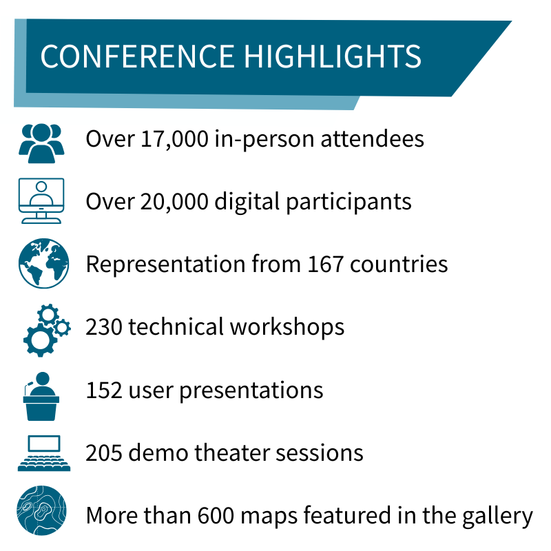
The Esri map gallery packs as much information as it does colorful imagery.
GIS has almost limitless capabilities that reach far beyond producing printed maps. I attended sessions not only on cartography, data analysis, and ArcGIS tools, but also on specialized topics such as public commenting workflows and accessibility.
One presenter demonstrated how her team uses ArcGIS to simulate the way maps appear to individuals with color blindness, helping ensure their products meet Section 508 accessibility standards. These kinds of tools are especially valuable on federally funded projects, where clear communication and effective public participation are essential.
AI Is Expanding
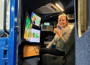
Becky gets in the driver’s seat to check out cutting edge GIS technology.
GIS will become even more valuable as AI expands, and Esri is at the forefront of developing GIS-specific AI software components. With the development of AI tools within ArcGIS products, users can expect more powerful analyses, increased efficiency, and broader accessibility. AI assistants and natural language tools are poised to make GIS more user-friendly, even for those without prior experience using ArcGIS.
The Esri User Conference continues to be a source of inspiration, innovation, and connection for GIS professionals around the world. From cutting edge technology to global collaboration, this year’s event reaffirmed the vital role GIS plays in addressing the complex challenges of our time. I’m excited to bring what I’ve learned back to my own work at Scout.
My colleagues and I at Scout can be counted on to provide high-quality GIS services to lead the way to your objective! If you have questions or need any support, contact us today at hello@scoutenv.com.